
Great news for GIAP (ICAC) in the last Marie Skłodowska-Curie Actions (MSCA) call from the European Union! The computational team will expand with a new project that aims at reconstructing the Roman transport network, and we are glad that our colleagues in Institut des Sciences de l’Évolution – Montpellier (ISEM UMR 5554), were awarded an MSCA that included a secondment in GIAP during the project.
We look forward to welcoming them in ICAC in Tarragona!

Reconstructing Roman Road Network for the understanding of Urban development (R3NUrb)
Fellow: Dr. Andrew McLean
Supervisors: Prof. Hèctor A. Orengo (ICREA Research Professor) and Dr. Alexandra Livarda (Ramón y Cajal Researcher)
Project abstract:
The Roman conquest, occupation and dominion over a large part of current Europe and beyond marked a strong change in social, cultural and economic patterns in the area. Two of the most important and lasting changes were the establishment of a new transport network and the large-scale development of cities. Connectivity continues to be seen as an essential factor in the analysis of the spread of urbanisation, migration, the ancient economy, and the transmission of ideas. In Antiquity connectivity could only be achieved via movement by land, river and sea, and had to rely on the available transport network. However, to date, no analysis of communication, trade, distribution of people and resources, or the economy in general, exists that actively considers the transport network, the single element that made connectivity possible, on an Empire-wide scale and therefore no attempts have been made to understand its influence on urbanism or its long-term influence. This is largely due to the lack of complete reconstructions of Roman route systems. Although much is known about the roads and other elements of the Roman transport network, this knowledge is partial and lacks integration. The road transport network is full of empty spaces and broken links that prevent the development of an integrated system fit for large-scale analyses and the use of quantitative and computational approaches.
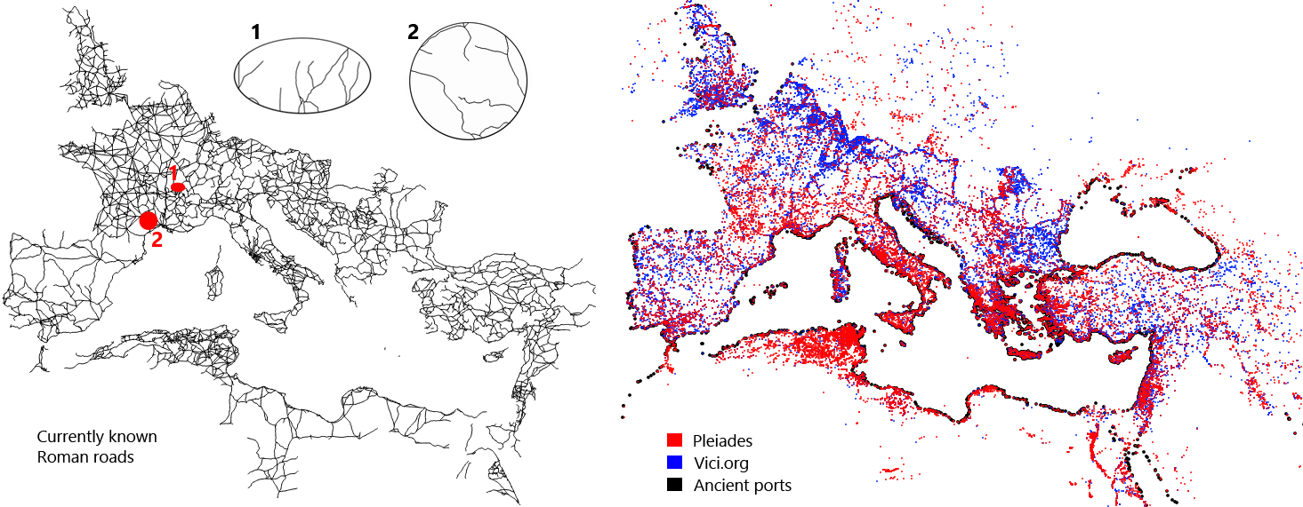
R3NUrb will address these problems by reconstructing the whole Roman transport network and using it to analyse the influence of connectivity on the process of urbanisation, urban distribution and the long term success of urban centres. For this R3NUrb will employ an innovative combination of computational approaches, remote sensing, network science, and geostatistics. This approach will provide unique insights into mobility, transport and urbanisation at a pan-Roman scale and, therefore, open up new horizons in the study of connectivity and urbanism in the past.
MSCA secondment at ICAC:

Fellow: Dr. Irene Tunno
Supervisor: Dr. Ana Ejarque (Institut des Sciences de l’Évolution – Montpellier ISEM UMR 5554, CNRS & Université de Montpellier)
Secondment supervisor: Prof. Hèctor A. Orengo (ICREA Research Professor at ICAC)
Secondment details:
Training in Landscape Archaeology techniques such as field survey, and archaeomorphological analysis; SMTVI, MSRM and multitemporal multisource machine learning classification for the detection of archaeological features –i.e. ancient roads, field systems, structures-, and palaeowetlands to conduct coring. The secondment includes training on geoarchaeological analyses. These will include basic notions in geomorphology and sedimentology, as well as interpretation of sedimentological and geochemical analysis and their application to the reconstruction of past hydrological and morphological dynamics in coastal areas that could be in relation with land-uses -i.e. soil erosion, eutrophication processes, shoreline evolution. Training will not aim to develop these analyses, but to understand their application, interpretation, and their coupling with palaeoecological analyses for the reconstruction of palaeolandscape change. The training will be accomplished through a four-month secondment with Dr Hèctor A. Orengo (ICREA Research Professor at ICAC), who is specialised on Landscape Archaeology and computational techniques, and Dr Alfredo Mayoral (ICAC), a postdoctoral geoarchaeologist conducting research in Abdera. This will be implemented by employing archaeo- and geoarchaeological datasets already available and/or being produced for Abdera and Emporion.
Project abstract:
Previous research on palaeolandscapes has overlooked a main driver of landscape change: the mobility of human societies. When groups move they take with them their technology and ideas, but also plants, or land-uses which merge with native environments and practices to give birth to transported landscapes. This can lead to significant and long-lasting landscape changes -i.e. deforestation, introduction of exotic plants, erosion- that can be traced back through the use of combined palaeoenvironmental and archaeological techniques. However, the study of transported landscapes and their environmental impact has only rarely been addressed so far, and it is especially needed in Mediterranean coastal areas where migratory and colonial processes have had a particularly active role in the modelling of landscapes for millennia. ACROSS will fill this existing gap in current research by analysing two areas at the two sides of the Mediterranean Basin: Abdera (Thrace) and Emporion (Catalonia). They account for a long history of prehistoric peopling, and have ancient colonial relationships with the foundation of the Greek colonies of Abdera and of Emporion by same cultural group, the Ionian tribe. An innovative approach combining multi-proxy palaeoecological analyses (pollen, non-pollen palynomorphs, plant macroremains, high-temporal fire reconstructions), and Landscape Archaeology datasets will be applied in both areas to reconstruct changes in vegetation, land-uses and landscapes following prehistoric migratory processes and colonial settling between the 6th millennia cal BC and the 4th century AD. A particular focus will be put in reconstructing landscape changes following Graeco-Roman colonial settling to assess 1) common and diverging trends in land-use and landscape shaping in culturally similar colonial landscapes over long distances, and 2) the interaction, integration and resilience of autochthonous and colonial practices and landscapes across the Mediterranean.

Funded by the European Union. Views and opinions expressed are however those of the author(s) only and do not necessarily reflect those of the European Union. Neither the European Union nor the granting authority can be held responsible for them.


